About the Park
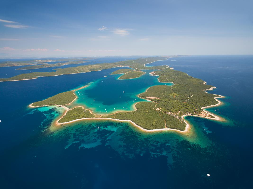
Telašćica Bay is located in the central part of the eastern coast of the Adriatic Sea, in the south-eastern part of the island of Dugi Otok. For its extreme beauty, richness and importance, this bay surrounded by 13 islands and islets, together with 6 islets inside the bay itself, was proclaimed a Nature Park in 1988. Telašćica acquired the status of a protected area already in 1980 because of its valuable flora and fauna, geological and geomorphological phenomena, versatile sea bottom life, and interesting archaeological heritage.
The area of Nature Park Telašćica is a distinctly contrasted area with quiet and peaceful beaches and a laid down coastline on one side, and wild and steep cliffs on the other, an area of Aleppo pine and holm oak forests on one side, and barren karst on the other, an area of cultivated fields covered in vineyards and olive groves, but also an area of degraded forms of vegetation covering dry habitats.
Three basic phenomena represent the basic characteristics of this area: the unique Telašćica Bay as the safest, most beautiful and largest natural port of the Adriatic with 25 small beaches, the cliffs of Dugi Otok or the so-called “stene” rising up to a height of 161 metres above the sea and reaching down to a depth of 90 metres, and the salt lake “Mir” with its medicinal properties. The most picturesque among the islands is the Katina Island, and the most unusual one is certainly Taljurić. The total surface area of the Nature Park is 70.50 km2, with 25.95 km2 on Dugi Otok and the neighbouring islets, and 44.55 km2 at sea. The environment is covered in beautiful cultivated meadows, and the hills are covered in rich Mediterranean flora with more than 500 plant species and an equally rich fauna. The underwater world counts more than 300 plant and 300 animal species.
The climate is characterised by more than 2 500 sunshine hours per year, an average temperature higher than 7°C in January, and an average annual temperature higher than 16°C. During winter the temperature of the sea is around 13°C, and during summer around 23°C. Remains of ancient buildings in Mala Proversa, as well as numerous pre-Romanesque churches, with St. John’s Church in Stivanje Polje as the most prominent one, are testimony that Telašćica has been populated since ancient times, and the first written record of fishing dating from the end of the 10th century is testimony that the beginnings of fishing in Croatia began precisely on these shores. Diving in the Nature Park is possible in several attractive locations near cliffs, and it is also possible to take walks around interesting places – be sure not to miss the beautiful view from the Grpašćak viewpoint. The above, and much more, has attracted and is attracting visitors to Telašćica Bay, which deservingly falls into the top category of protected nature parts as a Nature Park of the Republic of Croatia. Three national parks are located near Nature Park Telašćica: National Park Kornati, National Park Paklenica and National Park Krka, as well as two nature parks – Nature Park Vransko Jezero and Nature Park Velebit.
Basic information about Nature Park Telašćica
· COVERAGE: the southern part of Dugi Otok, the associated islets, and part of the maritime zone of Zadar County
· SURFACE AREA: total 70.50 km2 = 44.55 km 2 of sea + 25.95 km2 of land
· ACT AND YEAR OF FOUNDATION: the Act on the Proclamation of Nature Park “Telašćica” (Official Gazette “Narodne novine” 14/88) 1988
· GREATEST DEPTH OF TELAŠĆICA BAY: 67 m
· GREATEST HEIGHT “STENA”: Grpaščak 161 m
· GREATEST SEA DEPTH UNDERNEATH THE “STENA”: 85 m
· GREATEST HEIGHT: Mrzlovica 198 m
· NEAREST SETTLEMENT: Sali
· NAME: Telašćica – in the Middle Ages Tilagus – named for its resemblance to three adjoining lakes connected to one another.
Telašćica Bay
Telašćica Bay, after which the entire Nature Park is named, is located in the southeastern part of Dugi Otok Island. It is approximately 8 km recessed into the land, and in its southernmost widest part it is about 1.6 km wide. The part of the bay facing to the southeast opens up to the neighbouring islands of Kornati. The bay itself is very indented, counting 25 bays, capes, and 5 islets. Its position ensures protection from bura wind, a northern wind coming from the mainland, and jugo wind, a southern wind coming from the open sea. This makes Telašćica one of the largest and most protected natural ports of the eastern coast of the Adriatic. The very name Telašćica probably comes from the Latin expression “tre lagus”, which translates to “three lakes”. It consists of three parts which are separated from one another by a narrowing. The three parts are Tripuljak, Farfarikulac and Telašćica. Morphogenetically speaking, the three bays are in fact karst sinkholes covered by the sea ten thousand years ago after the last (Würm) glaciation.
The bottom of the bay is mostly covered in seagrass communities, habitats extremely rich in fauna, and significant for the propagation of many fish species.
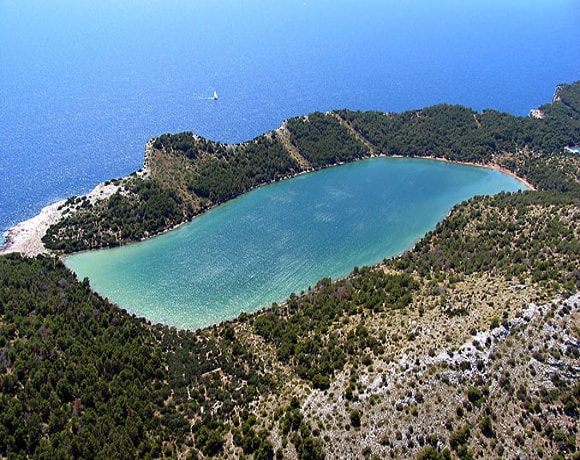
Salt lake Mir
Lake Mir is located in the southwestern part of Nature Park Telašćica. The lake is located in a narrow strip of land between Telašćica Bay and the open sea. After the last ice Age, the global sea level rose by approximately 120 metres, and the karst depression was filled by sea water through numerous underground microcracks, especially numerous on the northern side. The sea sources can easily be noticed at high tide. The lake is about 900 m long, and its greatest width is about 300 m. The greatest depth is 6 m. The lake is salty due to underground connections to the sea. The salinity of the lake is generally higher than the salinity of the surrounding sea due to evaporation and enclosedness. Very small water level changes have been noted because of the small permeability of the cracks connecting the lake to the sea. During stormy jugo wind, the sea spills over into the lake in its southeastern part. The lake shore is mostly low and rocky, with numerous limestone rocks, and only in the extreme southwestern part a lesser accumulation of sand can be observed. The bottom of the lake is rocky in the shallow parts, and covered in pelitic bottom deposits in the deeper ones, with fango (healing one) in one part.
Temperature fluctuations in the lake are very prominent (in summer to 33°C, in winter to 5°C), therefore the lake is warmer than the sea in summer, and colder in winter due to its shallowness. The salinity of the lake is above average due to evaporation. These extreme conditions are the reason for the biological poverty of the lake. In addition to the plankton, there are only a few species of marine organisms in the lake. These are: algae, goby, mullet, sea bass, several species of shellfish, see snails, crabs, and a special type of eel that grows up to 3 kg.
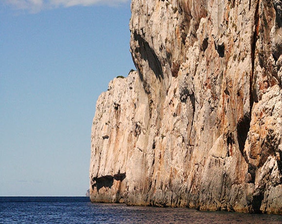
“Stene”
On the outer side of Telašćica Bay vertical cliffs rise into the most prominent steep slope of the Adriatic Sea – the famous “stene” of Dugi otok. The steep slope stretches from Cape Mrzlovica in the southwest to the mountainside of Veli Vrh in the southeast reaching a height of 161 m in Grpašćak. The greatest depths can reach 85 m. The area is rich in interesting flora and fauns, and dolphins may be seen swimming along the cliffs. Different corals, including the already endangered red corals, live underwater on the cliffs. The cliffs are interesting above sea level, too. Croatian Centaury (Centaurea ragusina) grows on the cliffs, which are also the northernmost habitat of tree spurge (Euphorbia dendroides). The cliffs are also a nesting place of the peregrine falcon (Falco peregrinus), and Eleonora’s falcon (Falco Eleonore). Because of the presence of a large number of birds of these two protected species, Telašćica has been included in the Important Bird Areas-IBA areas).
The cliffs of the steep slope are also home to two endemic species of land snails of the family of door snails (Clausiliidae): Delima edmibrani and Agathylla lamellosa. The Delima edmibrani has only been found within the boudaries of the Nature Park, therefore it could be considered as its endemic species, i.e. a stenoendemic species of the Nature Park.
The Croatian Centaury is a rare endemic species. It is present only in Croatia, in several locations, but with a scarce population: in areas around Cavtat, and in islands of Central and South Dalmatia. The species has two subvarieties in the area of Nature Park Telašćica: Centaurea ragusina ssp. ragusina located on steep slopes and in Čuška Dumboka Bay, and Centaurea ragusina ssp. lungensis which is present only on the steep slopes.
Along the cliffs, in the depths of the sea, you can find the Eunicella cavolinii and Paramuricea clavata gorgonians, and sponges such as Axinella cannabina. The underwater of the cliffs, to a depth of 20 km, is dominated by a community of photophyllic algae made of Halimeda tuna, Acetabularia acetabulum, Padina pavonica and many others. Colonies of red coral Corallium rubrum, which is an endangered species, can be found at greater depths. Several types of sea urchins, a large number of different species of fish and crabs also live in the area surrounding the cliffs.
The underwater hollows cliffs are featured with half-dark caves inhabited by a variety of sponges, cnidarians, corals, etc.
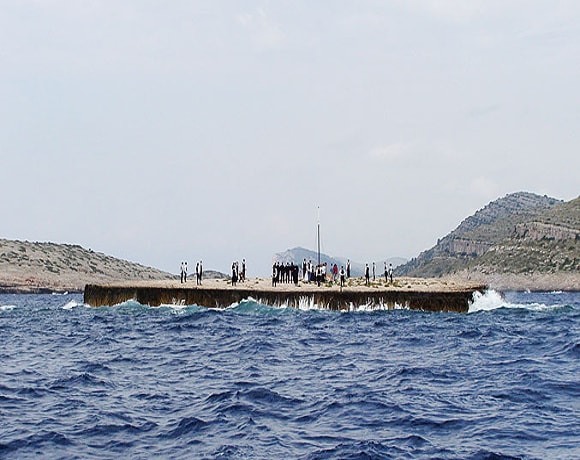
Taljurić
This unusual islet is actually a small stone plate with a diameter of about 60 m, and a height of only 3 m. It is made of horizontally stratified limestone whose upper layers were shattered by waves. From distance it looks like a flat surface, only 3high, and it resembles circular, flat board used in the kitchen and on boats. The sailors named it “tagliero” in a Venetian dialect, from which the diminutive “taljurić” was derived. During bad weather the entire rock is covered in sea foam, which is the reason for the lack of vegetation. A geological peculiarity of the island is a cave without a vault created by the melting or collapsing of the vault in the past. The sea around Taljurić is very rich in a variety of fish, especially deep-sea fish.